Malerweg © Kenny Scholz
Malerweg
- Length
- 119 km
- Ascent
- 4906 m
- Descent
- 4889 m
- Highest
- 539 m
- Difficulty
- 3 - Strenuous
- Duration
- 37 h
GPX
Map and Elevation
I have not yet hiked the Malerweg, but it is clearly a beautiful trail. What makes it even more interesting for me is how and why it made me change the formula I use to assess trail difficulty. The hollows or ‘Grund’ at the start of the trail, along with the numerous rocky outcrops, interacted with the formula to produce a result of 4906m gain and 4889m loss, and a hiking time of 62 hours along the 119km distance. I assume the 20x30m accuracy of the elevation data I use is not accurate enough to manage the drops into narrow gorges, rocky tunnels and the steep stairs and ladders encountered along the trail. I have introduced smoothing into my formula and applied that formula to all other trails, which seems to give a better result.
Pirna-Liebethal to Stadt Wehlen
The stage begins in Pirna-Liebethal and follows the Wesenitz through the narrow Liebethaler Grund, passing mills such as the Lochmühle and Daubemühle, as well as the Richard Wagner monument. After crossing the stream, the route climbs to Mühlsdorf and continues along forest-edge paths to the 51°N / 14°E coordinate marker.
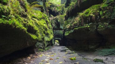
The trail then descends into the Uttewalder Grund, where steep rock walls and the natural rock gate define the landscape. From here, the route continues through the gorge towards Wehlen, where the stage finishes in the town with its historic structures and river setting.
Stadt Wehlen to Hohnstein
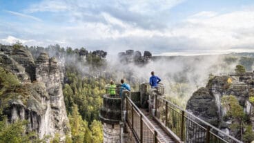
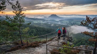
From Wehlen, the route initially follows the Elbe before climbing to the Steinerner Tisch, a historic stone rest point. The trail then continues along the Fremdenweg to the Bastei, one of the most prominent viewpoints in the region, before descending to Rathen.
The route continues through the Amselgrund, passing the Felsenbühne, Amselsee and the Amselfall waterfall, before reaching Rathewalde. From Hockstein, views open across the Polenztal before the trail descends through the Wolfsschlucht and climbs again via the Schindergraben to Hohnstein.
Hohnstein to Altendorf
From Hohnstein, the route descends past the remains of the Bear Garden and continues through forest along the Halbenweg and Räumichtweg to the Brand viewpoint, one of the most prominent panoramas on the Malerweg. From here, the trail drops steeply via steps into the Tiefer Grund before turning into the narrower Dorfgrund gorge and climbing towards Waitzdorf.
Beyond the village, the route follows quieter paths such as the Mühlweg and Kohlichtgraben, descending again into a wooded valley. Passing the former industrial site at Kohlmühle, the trail continues along the Sebnitz valley before finishing in Altendorf.
Altendorf to Neumannmühle
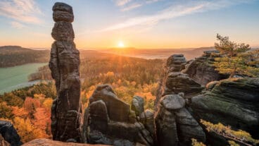
From Altendorf, the route descends through the Dorfbachklamm into the Kirnitzschtal and follows the Flößersteig towards Ostrauer Mühle. A sustained climb then leads via forest paths to the Schrammsteine, where narrow routes, ladders and ridge paths such as the Jägersteig and Schrammsteingratweg define one of the most rugged sections of the Malerweg.
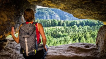
After passing viewpoints like the Schrammsteinaussicht and rock formations such as the Kleiner Dom, the trail continues to the Lichtenhainer Wasserfall. A further ascent leads to the Kuhstall rock cave, with an optional climb via the Himmelsleiter, before the route descends again into the valley to Neumannmühle.

Neumannmühle to Schmilka
From Neumannmühle, the route follows the Kirnitzsch upstream to Buschmühle before turning towards Arnstein and continuing via forest paths and roads to Räumichtmühle. The trail then crosses back towards the valley and climbs again past the Zeughaus, marking the transition to the main ascent of the stage.
A sustained climb via routes such as the Wolfsschlüchte, Roßsteig and Katzsteig leads to the summit of the Großer Winterberg, the highest point of the stage. From here, the route descends steadily through forest towards the Elbe valley, finishing in the village of Schmilka.
Schmilka to Kurort Gohrisch
From Schmilka, the route crosses the Elbe and climbs via the Aschersteig past the Kaiserkrone towards Schöna. The trail continues across open and forested terrain to Wolfsberg, where panoramic views open across the landscape, before reaching Reinhardtsdorf with its notable Baroque church.
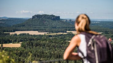
The route then follows a series of paths across ridges and woodland, passing Krippenberg and Liethenmühle before continuing towards the distinctive table mountains of Papststein and Gohrisch. After crossing these elevated sections, the trail leads to the stage finish in Kurort Gohrisch.
Kurort Gohrisch to Weißig
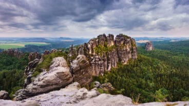
From Kurort Gohrisch, the route leads via forest paths to Pfaffendorf and climbs the Pfaffenstein via the narrow and steep “Nadelöhr” route. After descending, the trail continues past the Quirl and follows paths towards Königstein, where the fortress dominates the landscape above the town.
The route then continues along the base of the fortress and onwards to Thürmsdorf, passing the castle and the Malerweg Chapel with views back towards Königstein. The final section follows open field edges before reaching Weißig.
Weißig to Pirna
From Weißig, the route climbs to the Rauenstein and follows its narrow ridge, offering continuous panoramic views across the Elbe valley, surrounding cliffs and table mountains. The trail then descends towards Struppen-Naundorf, where a detour to the Robert Sterl House provides a cultural highlight.
The route continues along elevated paths above former quarries to the Königsnase viewpoint before descending to the Elbe. Following the riverside paths and the Canalettoweg, the trail leads into Pirna, finishing at the market square.