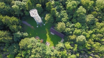
Donauberglandweg © Thomas Bichler
Donauberglandweg
- Length
- 61 km
- Ascent
- 1898 m
- Descent
- 2068 m
- Highest
- 1014 m
- Difficulty
- 3 - Strenuous
- Duration
- 18 h
GPX
Map and Elevation
I walked this trail in 2024. The Donauberglandweg has very few huts. It is very short and could possibly be done in a single day, however a potential “hut” is the Gansnest tower about 42km into the trail. It is considered a “Leading Quality Trail – Best of Europe” by the European Ramblers Association (ERA).
Lemberg to Dreifaltigkeitsberg
The stage begins at the foot of the Lemberg with a steady ascent to the highest point of the Swabian Alb. From the summit tower, wide panoramic views extend across southern Germany and, in clear conditions, as far as the Alps. The route continues via Wehingen and climbs again to the Kehlen, before following the elevated ridge line of the Alb.
Continuing along the escarpment, the trail crosses the Hummelsberg and reaches the open plateau of the Klippeneck, known for its glider airfield and exposed viewpoints. The stage concludes at the Dreifaltigkeitsberg, where the monastery and church sit above the valley, marking the end of the section before the descent towards Spaichingen.
Dreifaltigkeitsberg to Mühlheim an der Donau
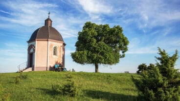
From the Dreifaltigkeitsberg, the route crosses the open Alb plateau towards the Alten Berg, where juniper heathland and the Josefskapelle mark a prominent viewpoint with wide alpine panoramas in clear conditions. Passing near Böttingen, the trail descends through the quiet Schäfertal, where the Grauentalquelle offers a natural resting point.
The path continues via the Allenspacher Hof before descending along the valley edge into the narrow Lippachtal, passing viewpoints such as the Glatter Felsen. Following the valley floor past the Lippachmühle, the route leads on to Mühlheim an der Donau, where the historic town sits above the river on a prominent ridge.

Mühlheim an der Donau to Fridingen an der Donau
From Mühlheim, the route climbs steeply out of the Danube valley to reach viewpoints such as the Gelber Fels and passes near the Mühlheimer Felsenhöhle. Crossing the Hintelestal, known for its seasonal wildflowers, the trail continues to the Kolbinger Höhle, a notable cave system, before leading through forest to the Gansnest tower with wide views over the surrounding landscape.
After descending towards Fridingen, the route climbs again to the Knopfmacherfelsen, one of the most prominent viewpoints of the stage, overlooking the upper Danube valley. The trail then continues along the plateau past further rock viewpoints such as the Stiegelesfelsen and Laibfelsen before descending into the historic centre of Fridingen.
Fridingen an der Donau to Beuron
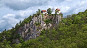
From Fridingen, the route enters the Upper Danube Valley, following paths through a landscape of steep rock formations and forested slopes. After an initial ascent, the trail passes through the Wolfental and leads to the ruins of Kallenberg, a prominent viewpoint over the valley, before continuing through woodland to the exposed position of Schloss Bronnen above the Danube.
The route then descends towards the valley floor, passing cave sites and the Jägerhaus before climbing again into the Liebfrauental with its grotto and pilgrimage path. The final section follows the Danube into Beuron, where the stage ends at the abbey complex and nature centre in the heart of the valley.
Trail Certification

Quality Trail
A Long-Distance Quality Trail meets high national standards for attractive hiking routes. These trails are carefully maintained, clearly marked, and designed to protect nature while providing a high-quality hiking experience. Regional experts monitor the trails, and they are reassessed every three years by the German Hiking Association based on criteria such as trail structure, signage, landscape, culture, and infrastructure.
Best of Europe
The “Leading Quality Trails – Best of Europe” label is a Europe-wide certification for outstanding long-distance hiking trails. Certified routes meet strict standards for trail quality, signage, and natural surroundings. They guide hikers along varied natural paths through impressive landscapes, picturesque towns, and cultural landmarks. The certification is awarded by the European Hiking Federation.