Eggeweg © Andreas Hub
Eggeweg
- Length
- 71 km
- Ascent
- 1311 m
- Descent
- 1339 m
- Highest
- 464 m
- Difficulty
- 2 - Moderate
- Duration
- 20 h
GPX
Map and Elevation
I walked this trail in 2023. The official start of the Eggeweg are the Extersteine in the Teutoburg Forest which are closest to the town of Horn-Bad Meinberg. I’ve also added an extension to the trail to Detmold that includes the Hermannsdenkmal, which would be a shame to miss if you’re so close by. When the Eggeweg is combined with the Hermannsweg it becomes the Hermannshöhen long-distance trail.
Externsteine to Bad Driburg
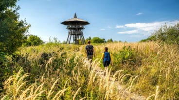
The stage begins at the Externsteine and heads south through the Silberbachtal, climbing steadily through forest onto the Egge ridge. The trail follows natural paths through beech woodland, frequently reaching the steep escarpment edge, where karst features such as sinkholes and caves highlight the geological character of the region.
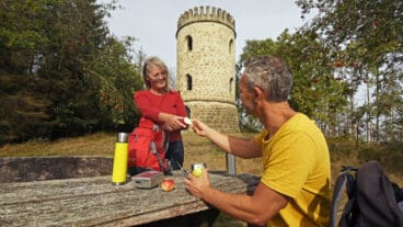
The route continues to the twin summits of the Lippsche Velmerstot and Preußische Velmerstot where the Eggeturm marks the highest point of the Eggegebirge. From here, the trail passes features such as the Bedastein and Schwarzes Kreuz before continuing along the ridge and descending towards Bad Driburg, finishing near the Iburg with views from the Sachsenklause.
Bad Driburg to Grunewald
From the Iburg above Bad Driburg, the route follows the Egge ridge southwards, staying close to the escarpment with repeated views over the surrounding landscape. The trail passes karst features such as dolines near the Klusenberg before continuing through forest towards Herbram-Wald.
Beyond this, the path follows the Klippenweg along the ridge past the Teutoniaklippen toward Willebadessen, passing landmarks such as the Alte Eisenbahn, Kleiner Herrgott and the prominent Bierbaums Nagel viewpoint tower. The stage continues through open and forested sections before ending near the B 68.

Grunewald to Marsberg
From the Grunewald parking area, the route continues south along the Hardehauser Klippen, following the ridge with sections close to the escarpment. The trail reaches the Nadel before descending steeply into the Schwarzbachtal and climbing again towards the deserted settlement of Blankenrode, where the landscape opens around the Bleikuhlen with their distinctive geological features.
The route then continues via Oesdorf with views into the Diemel valley and passes through Essentho before joining the historic Via Regia. Following this old trade route, the trail descends towards the Diemel and finishes near Marsberg.
Trail Certification

Quality Trail
A Long-Distance Quality Trail meets high national standards for attractive hiking routes. These trails are carefully maintained, clearly marked, and designed to protect nature while providing a high-quality hiking experience. Regional experts monitor the trails, and they are reassessed every three years by the German Hiking Association based on criteria such as trail structure, signage, landscape, culture, and infrastructure.