Eifelsteig © BY-SA Eifel Tourismus GmbH
Eifelsteig
- Length
- 315 km
- Ascent
- 8621 m
- Descent
- 8769 m
- Highest
- 658 m
- Difficulty
- 3 - Strenuous
- Duration
- 91 h
GPX
Map and Elevation
I walked this trail in 2025 from Kornelimünster, but took the Lieserpfad to Wittlich later in the trail, having experienced the trail between Kordel and Trier before. The Eifelsteig officially begins in Kornelimünster and proceeds in a southerly direction to Trier. I have extended the trail from Kornelimünster to Aachen following the Krönungsweg, and into the city center where it passes by the famous Cathedral of Aachen and some other points of interest. I have added a few detours to my GPX, including a walk through Vogelsang IP, a visit to the Helenenquelle in Gerolstein, and a climb around the Niederburg and Oberburg castles in Manderschied. There are several trail closures and detours due to flooding and other damage including the walk through the Butzerbach valley between Kordel and Trier, so check the current track status before you leave.
Kornelimünster to Roetgen
The stage begins in Kornelimünster at the historic abbey, following the Inde through the village before passing views of the Itertalviadukt. A steady ascent then leads out of the valley towards Hahn and Friesenrath, where the route passes the St. Bernhard Chapel and continues into the forest near Rott.
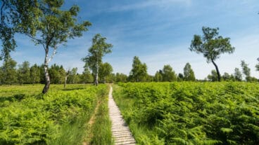
From here, the trail crosses the Struffelt nature reserve on boardwalks through open heathland before reaching viewpoints over the Dreilägerbachtalsperre. The route then descends towards Roetgen, finishing along a narrow path that follows the line of the former Vennbahn railway.

Roetgen to Monschau
From Roetgen, the route crosses the former Vennbahn line and briefly enters a German exclave before continuing into Belgium and the open moorland of the Hohes Venn. The trail passes the remains of Reinartzhof and crosses this exposed landscape, with features such as the Vennkreuze marking historical points along the way.
After a rest opportunity at the Steling shelter, the route returns to Germany, passing the legendary “Kaiser Karls Bettstatt” stone. The final section follows traces of the Vennbahn before descending into the narrow streets of Monschau, where the stage ends in the historic town centre.
Monschau to Einruhr
From Monschau, the route climbs out of the Rur valley to viewpoints above the town before continuing along forest paths into the Perlenbachtal. The trail then follows the eastern shore of the Perlenbachtalsperre, leading to Höfen, where the National Park gate marks the transition into the Eifel National Park area.
Beyond Höfen, the route passes through the characteristic hedge landscape before descending through the Kluckbachtal back towards the Rur valley. The trail continues along elevated paths with viewpoints such as Perdsley and Uhusley, before reaching the final viewpoint at Wolfshügel and descending to Einruhr on the shores of the Obersee.
Einruhr to Gemünd
From Einruhr, the route climbs gently with views over the Obersee before entering the Eifel National Park. The trail follows natural paths along the confluence of the Urft and Rur, leading to the Urft dam, where the crossing offers open views across the reservoir and surrounding landscape.
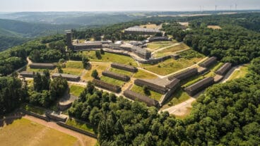
A steep ascent then leads to the Dreiborner Hochfläche, an open plateau shaped by its former military use, where the abandoned village of Wollseifen marks a key historical point. The route continues past the Ordensburg Vogelsang IP complex and along viewpoints such as Kickley and Modenhübel before descending into the Urft valley and finishing in Gemünd.
Gemünd to Steinfeld
From Gemünd, the route follows the Olef valley, gradually climbing out of the Urft valley on forest paths. The trail reaches the Kuckucksley viewpoint, offering wide views across the Oleftal, before descending into the village of Olef, where the historic railway line crosses directly through the centre.
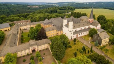
The route then leaves the valley with a gentle ascent through mixed woodland, passing Golbach and following sections along the Kallbach. The final part of the stage becomes more open and agricultural, leading to Steinfeld Abbey, where the basilica marks the end of the stage.
Steinfeld to Blankenheim
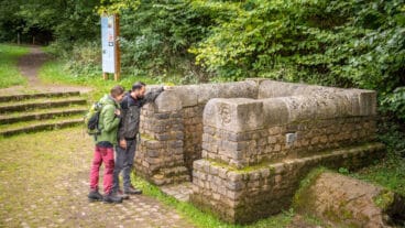
From Steinfeld, the route crosses the Gillesbach and climbs along the Königsberg, offering a final view back towards the abbey before descending into the Urft valley. Along the river, the trail reaches the Grüner Pütz, a preserved Roman spring that once supplied water to Cologne, marking the historical focus of this stage.
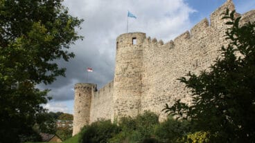
The route continues along the Urft towards Nettersheim, passing sites such as the Mannenberghöhlen and the Römerweiher before reaching the Roman site at Steinrütsch. A final section through woodland leads to Blankenheim, where the stage ends below the castle overlooking the town.
Blankenheim to Mirbach
From Blankenheim, the route passes through the historic centre and the Ahrquelle before continuing through forest on the Brotpfad. The trail leads through the Schaafbachtal towards Ripsdorf and then across open farmland to Alendorf, where a chapel marks the start of the ascent to the Kalvarienberg.
From the summit, the route crosses juniper heathland before descending into the Lampertstal and crossing into Rhineland-Palatinate. The final section follows the Mirbach stream to the village of Mirbach, where the stage ends at the Erlöserkapelle.
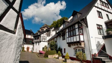
Mirbach to Hillesheim
From Mirbach, the route leaves the Erlöserkapelle and follows narrow forest paths, passing several large shelters and continuing through quiet woodland. The trail descends into the Mühlenbach valley, where the Dreimühlen-Wasserfall forms a notable natural highlight with its distinctive tufa formations.
The route then continues on well-developed paths to Kloster Niederehe and on to Burg Kerpen, which overlooks the surrounding landscape from a rocky ridge. Passing near Berndorf, the stage finishes in Hillesheim, a small town with a distinctive literary theme.
Hillesheim to Gerolstein
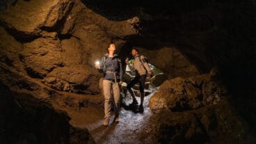
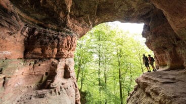
From Hillesheim, the route begins along the historic town wall before entering the Bolsdorfer Tälchen, where a mix of water, limestone formations and open valley scenery defines the landscape. The trail then reaches the Kyll, crossing the river before climbing steadily through forest to the Mühlsteinhöhle cave at Rother Kopf.
After descending and crossing the Auberg, the route approaches Gerolstein but detours to the Gerolsteiner Dolomiten, a series of striking limestone formations with wide views. The stage continues past the Buchenloch cave and the Papenkaule volcanic crater before descending in switchbacks into the Kyll valley and finishing in Gerolstein.
Gerolstein to Daun
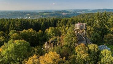
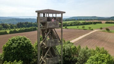
From Gerolstein, the route climbs steeply out of the Kyll valley, passing the ruins of the Löwenburg with views over the town. A sustained ascent leads to the Dietzenley, where an observation tower marks one of the highest points of the stage, followed by more undulating forest paths.
The trail continues through woodland towards Neroth before descending into the Kleine Kyll valley and climbing again to the Nerother Kopf. A final ascent over a wooded ridge leads to Daun, completing a stage defined by repeated climbs and varied terrain.
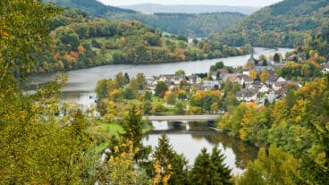
Daun to Manderscheid
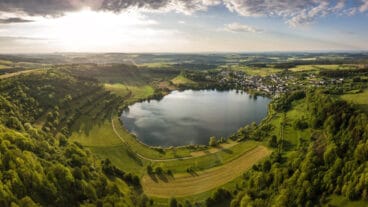
From Daun, the route follows the Liesertal before climbing to the Gemündener Maar, the first of the volcanic crater lakes on this stage. The trail continues to the Mäuseberg, where the Dronketurm provides views over the surrounding maars, before circling the Weinfelder Maar and continuing towards the Schalkenmehrener Maar.
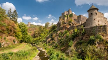
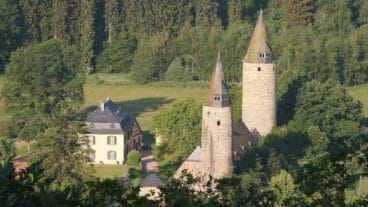
After descending into Schalkenmehren, the route enters the quieter upper Liesertal, following a long, uninterrupted valley section through forest and open landscape. The stage finishes near Manderscheid, where the twin castles overlook the valley from above.
Manderscheid to Kloster Himmerod
Passing views of the Oberburg and Niederburg in Manderscheid, the stage continues from the Liesertal, following narrow paths along the wooded slopes of the valley. The trail remains close to the river for much of the route, with shelters like the Balduinshütte providing natural rest points, before gradually leaving the valley and following the Ilgenbach through quiet forest.
After a brief transition into more open farmland, views open across the rolling Eifel landscape towards Großlittgen. The stage finishes at Himmerod Abbey, where the monastery complex and its Baroque church form a clear endpoint.
Kloster Himmerod to Bruch
From Himmerod Abbey, the route follows the Salm valley, continuing through a quiet and largely undeveloped landscape. The trail runs close to the river with gentle gradients, passing historic mills and rock formations along the valley sides.
Apart from a brief passage near Landscheid and the crossing beneath a motorway, the stage remains largely uninterrupted by settlements. The route continues along the Salm to the village of Bruch, where the stage ends near Burg Bruch overlooking the valley.
Bruch to Kordel
From Bruch, the route leaves the Salm valley with an initial climb onto higher ground near Zemmer. The trail then follows a mix of forest paths and open farmland, passing through small settlements and maintaining a steady, undulating profile across the plateau.
The viewing tower Zemmer along the route offers wide vista towards the Hunsrück before the trail descends into the Kyll valley. A final short climb is followed by a descent in switchbacks, leading into Kordel and marking the end of the stage.
Kordel to Trier
From Kordel, the route follows the Kyll valley before entering the Butzerbachtal, where streams, small waterfalls and rope bridges define the character of the trail. The path then climbs out of the valley, passing the Pützlöcher, remnants of Roman mining, and continues to Burg Ramstein and nearby cave formations such as the Klausenhöhle and Genovevahöhle.
The final section leads towards the Mosel valley, where elevated paths offer wide views over the river near Biewer. The trail continues along a narrow cliff path to the Weisshaus, marking the official end of the Eifelsteig, before an access path leads down into Trier.
Trail Certification
Premium Hiking Trail
Premium Hiking Trails are routes that offer an exceptional hiking experience. They are carefully marked and designed to provide varied scenery and cultural highlights. The trails are evaluated using criteria that measure both the quality of the path and its surroundings. Certification by the German Hiking Institute is based on an objective assessment to ensure a consistently high-quality hiking experience.