AhrSteig © Dominik Ketz
AhrSteig
- Length
- 108 km
- Ascent
- 3387 m
- Descent
- 3801 m
- Highest
- 611 m
- Difficulty
- 3 - Strenuous
- Duration
- 33 h
GPX
Map and Elevation
I walked this trail in 2023 and have a few recommendations to detour from the main route. If you want to walk the the complete AhrSteig from Blankenheim to Sinzig, I recommend taking the detours shown here to the Rotweinwanderweg via the Teufelsloch and Altenahr, and then rejoining the AhrSteig at the Saffenburg. If you are only planning to visit the area once in your life, then I recommend skipping the section between Blankenheim and Altenahr, and instead starting the trail in Sinzig, walking the AhrSteig to Altenahr via the Teufelsloch, then walking to Bad Bodendorf via the Rotweinwanderweg. The Rotweinwanderweg between Altenahr and Mayschoß shouldn’t be missed.
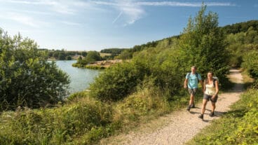
Blankenheim to Freilinger See
The stage begins in the centre of Blankenheim at the Ahrquelle, passing through the historic old town with its half-timbered houses before following the young Ahr past the Schwanenweiher. After a railway underpass, the route climbs steadily through forest to the plateau of Birker Berg, where the first wide views over the Eifel landscape open up.
The trail continues across open sections and woodland towards the Bohrsberg, maintaining elevated views over the surrounding hills. From here, the route gradually descends, finishing at the lakeshore of Freilinger See.
Freilinger See to Aremberg
From Freilinger See, the route climbs steadily via meadow paths to the Hühnerberg, where a summit cross marks a wide panoramic viewpoint over the Eifel, including views towards the Hohe Acht. The trail then continues across the open plateau of Am Gericht before entering a more sheltered forest landscape.
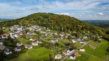
Following sections of an old Roman road, the path leads through quiet woodland and into the Aulbach valley before climbing again towards Aremberg. Along the way, the Guardian Angel Chapel marks a transition back into more open terrain, where views extend towards Nürburg and the surrounding highlands before reaching the village.
Aremberg to Insul
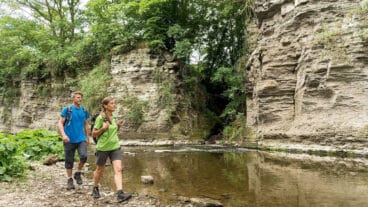
From Aremberg, the route climbs to the ruins of Arenberg Castle, the highest point of the entire AhrSteig, before descending through forest to Eichenbach. After crossing the Ahr near Streitenau, the character of the trail becomes more rugged, with a steep ascent through the Schulder Hardt leading onto narrow paths along exposed sandstone cliffs and rocky sections above the valley.
The trail drops into Schuld, where views of the Ahr loop open up, before climbing again through forest to the Spicher Ley, a prominent rock formation with wide views across the valley. The final section descends through woodland to Insul, passing the natural rock formation of the Prümer Tor and the Hahnensteiner Mühle along the way.
Insul to Kreuzberg
From Insul, the route climbs steadily through forest to Sierscheid before opening out onto the Dümpelhardt plateau, one of the most expansive viewpoints of the AhrSteig. The trail then descends through meadows and woodland into the Liersbach valley before beginning a longer ascent towards the Hönninger plateau.
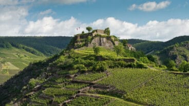
Continuing via Linder Höhe, where panoramic views extend across the Ahr hills, the route passes the nearby Crib Chapel before descending on forest paths into the Ahr valley, marking the start of the wine-growing region. The stage officially finishes in Kreuzberg, overlooked by its prominent hilltop castle, however I recommend you continue past the Teufelsloch to Altenahr.
Kreuzberg to Walporzheim
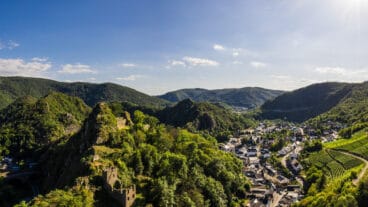
From Kreuzberg, the route climbs on narrow paths into a more rugged landscape, with an optional detour to the Teufelsloch offering views over Altenahr and the Ahr loop. The trail continues uphill to the Schrock viewpoint before running between forest and vineyards towards the Saffenburg ruins, where a wide panorama opens across the valley and surrounding hills.
Beyond Rech, the route passes through vineyards and woodland before ascending to the Krausberg, where a tower marks another key viewpoint over the Ahr region. The final section descends through mixed forest, passing the Bunte Kuh rock formation, before reaching Walporzheim.

Walporzheim to Bad Neuenahr
From Walporzheim, the route enters the quiet Heckenbachtal, following shaded paths along the stream past the Heckenbach chapel and towards the Maibachklamm. A short detour leads to the Katzley viewpoint, offering views over the Ahr valley, before the trail continues through woodland and into the vineyards above Bad Neuenahr.
The path climbs steadily before descending into the Bachemer Bach valley, where the Lourdes Chapel marks a sheltered stopping point. A final ascent leads to viewpoints above the vineyards, before the route passes the Paradieswiese and forest climbing park and descends into Bad Neuenahr.
Bad Neuenahr to Sinzig
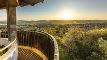
From Bad Neuenahr, the route climbs through forest to the Neuenahrer Berg, where an observation tower offers views across the Ahr valley and towards the Siebengebirge. The trail then descends into the Idienbachtal before climbing again on narrow paths towards the open landscape around Heimersheim and Ehlingen.
From the Ehlinger Ley, the route follows a more level ridge section along the Mühlenberg, with occasional views opening towards the Rhine valley. A final climb leads to the Feltenturm, providing one last panoramic viewpoint, before the trail descends to Sinzig, finishing near the castle and St. Peter’s Basilica.