

DeWandelaar in the Harz © DeWandelaar
Multi-Day Hiking in Germany
DeWandelaar is a personal blog dedicated to planning and sharing multi-day hiking trips in Germany, with a focus on GPS route creation and gear selection. GPX files are updated at the start of each hiking season.
The map below shows all completed and planned trails. Click the hiker icon to view the track name, then follow the link to access detailed trail information, including data, GPX downloads, maps with highlights, and stage overviews.
Maps & GPX Files
DeWandelaar creates GPX tracks with accurate latitude, longitude and elevation data. Trail difficulty is calculated to help search and filter long-distance trails according to fitness and ability.
Featured Long-Distance Trails
When selecting long-distance hiking trails in Germany, I prioritize varied landscapes, protected nature areas, and cultural or historical points of interest. Reliable water sources, trail shelters and resupply points improve hiking logistics, while guesthouses and DJH hostels allow for flexible and sociable accommodation. A scenic biergarten, vineyard, or traditional restaurant at the end of a stage enhances the overall hiking experience.

Pfälzer Waldpfad
The Pfälzer Waldpfad crosses one of Germany’s largest continuous forest regions and offers a classic multi-day thru-hike with minimal road exposure. Highlights include the remote Luitpoldturm lookout tower with integrated shelter facilities, dramatic sandstone cliffs, and numerous castle ruins along the route. The trail concludes at the Deutsches Weintor, the symbolic gateway to the Palatinate wine region, making it one of the most diverse long-distance hikes in Germany.
143km
4373m
4403m
606m
Medium
34h

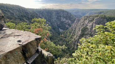
Harzer-Hexen-Stieg
The Harzer-Hexen-Stieg delivers geological, industrial, and cultural diversity within a compact long-distance hiking route. The trail crosses the UNESCO-listed Upper Harz Water Management System, ascends the Brocken — the highest peak in northern Germany — and passes the former inner-German border. A detour to the Titan-RT suspension bridge and a finish through the Bode Gorge before reaching medieval Quedlinburg create a well-balanced multi-day hiking experience.
101km
2647m
2683m
1140m
Medium
22h

AhrStieg
The AhrSteig combines forested ridge walking with expansive vineyard panoramas in western Germany. A recommended 80 km variation starts in Sinzig, follows the AhrSteig to Altenahr, and returns via the Rotweinwanderweg (Red Wine Trail). Along the route are Roman ruins, Cold War relics, castle remains, scenic towers, wineries, and traditional wine villages. The elevation profile and open valley views make it one of Germany’s most distinctive multi-day hiking routes.
108km
3610m
4041m
611m
Strenuous
26h
About
My hiking name is DeWandelaar. I solo hike trails in Germany between April and September, and update this website over winter. Use interactive map icons to access trail pages and free downloads.