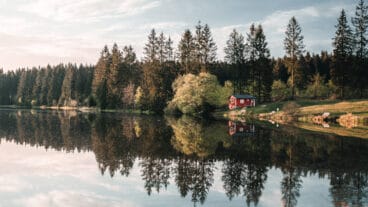
Harzer-Hexen-Stieg © DeWandelaar.Org
Harzer-Hexen-Stieg
- Length
- 100 km
- Ascent
- 2129 m
- Descent
- 2171 m
- Highest
- 1140 m
- Difficulty
- 2 - Moderate
- Duration
- 28 h
GPX
Map and Elevation
I walked this trail in 2023, taking the main trail to Konigshütte, then the Südvariante and Titan-RT to Rübeland, and finally from there to Thale on the main trail. The Harzer-Hexen-Stieg trail proceeds from west to east over the Brocken. The Brockenumgehung option detours from the main trail at Torfhaus, and bypasses the Brocken as it proceeds through Sankt Andreasberg and Braunlage and re-joins the main trail just northwest of Konigshütte. The Südvariante detours from the main trail at Konigshütte and passes through Stadt Hasselfelde before re-joining the main trail at Altenbrak. The Titan RT is a recommended detour to take you over the paid suspension bridge, see the Titan-RT website for costs and other information. I have linked the Titan-RT route to the Südvariante as there is a good hut and views over Altenbrak along the trail.
Osterode am Harz to Buntenbock
The stage begins in the historic town of Osterode, following old trade routes that once supplied the mining region of the Upper Harz. The trail climbs steadily through a mix of open landscape and forest, passing landmarks such as the Eselsplatz before continuing along the historic Hundscher Weg.
As the route gains elevation, viewpoints such as the Marienblick offer views over the Lerbachtal. The landscape gradually transitions into the typical Upper Harz plateau, characterised by forests, mining ponds and open meadows, before reaching Buntenbock.
Buntenbock to Torfhaus
From Buntenbock, the route crosses the Clausthal upland, where the landscape is shaped by the historic Oberharzer Wasserwirtschaft, a network of ponds, dams and channels once used for mining. Landmarks such as the Sperberhaier Damm and Dammgraben accompany the trail, while information boards and traditional markers highlight the engineering heritage of the region.
Beyond Altenau, the trail enters the Harz National Park, where the character becomes wilder and more natural. The path follows narrow and sometimes steeper routes through regenerating forest before climbing towards Torfhaus, where views open towards the Brocken, the highest peak of the Harz.
Torfhaus to Drei Annen Hohe
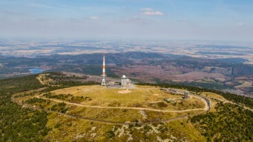
From Torfhaus, the route follows the Goetheweg towards the Brocken, with open views across the high moor landscape of the Harz. The trail follows the line of the former inner-German border, now part of the “Grünes Band”, before reaching the summit of the Brocken, the highest point of the entire trail.
From the summit, the route descends through the National Park, passing granite rock formations such as the Ahrensklint and Trudenstein above Schierke. The trail continues on quieter forest paths towards Drei Annen Hohne, where the stage ends at the junction of the Harz narrow-gauge railway.

Drei Annen Hohe to Altenbrak
From Drei Annen Hohne, the route descends through the Steinbachtal to Königshütte, where the Warme and Kalte Bode meet near the ruins of the Königsburg. Following the river, the trail leads through forest and open valley sections before climbing towards Rübeland, known for its famous stalactite caves and mining history, with viewpoints such as Hoher Kleef offering wider views across the landscape.
Beyond Rübeland, the route follows the Bode through a varied reservoir landscape, passing the Wendefurther Talsperre and the imposing Rappbode dam. The river then narrows again into a more natural valley, guiding the final section of the stage into Altenbrak.
Altenbrak to Thale
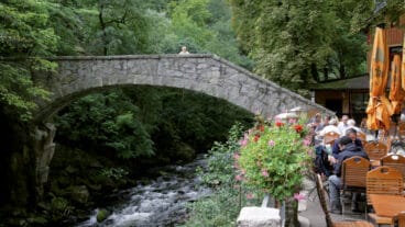
From Altenbrak, the route follows the Bode towards Treseburg, where the trail enters the Bodetal nature reserve. The valley gradually narrows into a dramatic gorge, with steep granite cliffs rising on both sides and the path becoming more rugged as it follows the river closely through one of the most striking landscapes in the Harz.
As the trail continues through the gorge, viewpoints such as the Roßtrappe and Hexentanzplatz rise high above the valley, offering optional detours with wide views. Towards the end of the stage, the valley opens out and the route leads into Thale, marking the end of the trail.
Trail Certification

Quality Trail
A Long-Distance Quality Trail meets high national standards for attractive hiking routes. These trails are carefully maintained, clearly marked, and designed to protect nature while providing a high-quality hiking experience. Regional experts monitor the trails, and they are reassessed every three years by the German Hiking Association based on criteria such as trail structure, signage, landscape, culture, and infrastructure.