Lieserpfad © Dominik Ketz
Lieserpfad
- Length
- 76 km
- Ascent
- 1878 m
- Descent
- 2269 m
- Highest
- 576 m
- Difficulty
- 2 - Moderate
- Duration
- 21 h
GPX
Map and Elevation
The Lieserpfad and the Eifelsteig share a section of their respective trails between Daun and south of Manderscheid. I walked the section from Daun to Wittlich in 2025. The shelters along that stretch are some of the best I have ever encountered on German long-distance trails, and the section through the forest around Manderschied is one of my favourite hikes in Germany.
I recommend doing the detour around the Niederburg Mandershied that I have included in the Lieserpfad GPX. You could consider joining the Eifelsteig at Daun and crossing over the volcano cones; the trail will rejoin the Lieserpfad before Manderschied.
Boxberg to Daun
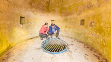
This opening stage of the Lieserpfad begins at the Lieserquelle near Boxberg and follows the young river through the varied landscape of the Eifel. The route passes through the Struth, offering views toward the Hilgerather Kirche, and continues across open fields and lightly wooded sections. Along the way, hikers encounter volcanic features such as the carbonated mineral springs (“Dreese”) at Neichen and Rengen, where the slightly acidic water can be sampled.
The trail maintains a gentle, varied profile as it leads via Nerdlen toward Daun. A notable rest point is the protected ancient oak between Neichen and Nerdlen, providing a natural pause along the route. The stage concludes in the spa town of Daun, where cafés and local attractions—such as the volcanic heritage of the region—offer opportunities to end the hike comfortably.
Daun to Manderschied
This stage leads from Daun into the volcanic landscapes of the Eifel, beginning with the scenic Gemündener Maar. The trail follows the Lieser through a quiet valley characterised by open meadows and later by light oak woodlands, offering a calm and largely undisturbed hiking experience. The terrain is varied, with gentle sections along the valley floor interspersed with occasional steeper passages.
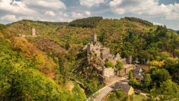
As the route approaches Manderscheid, it transitions to a more rugged profile, including a rocky path above the river. Viewpoints on the trail offer wide views across the valley before the stage culminates at the impressive Manderscheider Burgen, which dominate the landscape and form the historical highlight of the stage.
Manderschied to Wittlich
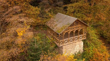
This longest and most demanding stage begins at the Manderscheider Burgen and follows the Lieser through a rugged valley landscape. The route is characterised by narrow, often steep paths along slate cliffs, interspersed with ascents and descents through dense woodland. Elevated sections provide repeated panoramic views over the valley and surrounding forests, particularly from viewpoints such as the Balduinshütte and Robertskanzel. The terrain requires good fitness, with continuous elevation changes defining the stage.
Further along, the trail alternates between forested slopes, open clearings, and sections directly along the river, passing landmarks such as the Burgberg near Karl and the Pleiner Mühle. As the route approaches Wittlich, the landscape becomes more open, and the demanding terrain gradually eases. The stage concludes in the historic town centre of Wittlich, providing a clear transition from remote valley scenery to an urban setting.
Wittlich to Lieser an der Mosel
This final stage of the Lieserpfad leads from Wittlich across the open landscape of the Wittlicher Senke toward the Moselle valley. The route passes varied terrain, including sandstone formations in the Plattener Schweiz and archaeological sites such as a Roman villa. Along the way, the path alternates between forest sections and more open countryside, gradually introducing the characteristic vineyard scenery of the Moselle region.
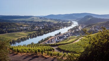
Continuing past the Klostermühle Siebenborn, the trail follows the now fully developed Lieser river toward its confluence. The landscape becomes increasingly shaped by viticulture, with wine hills and villages marking the approach to Lieser an der Mosel. The stage concludes at the Moselle, near landmarks such as Schloss Lieser, providing a clear and scenic endpoint to the route.