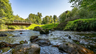
Albsteig Schwarzwald © Martin Boehm
Albsteig Schwarzwald
- Length
- 84 km
- Ascent
- 3195 m
- Descent
- 2799 m
- Highest
- 1414 m
- Difficulty
- 3 - Strenuous
- Duration
- 25 h
GPX
Map and Elevation
I haven’t walked this trail yet, the map and GPX are a summary of my research so far. My idea is to walk the Schluchtensteig from Stühlingen to St. Blasien, take public transport to Albbruck, walk the Albsteig West to Feldberg, return to St. Blasien via the Albsteig Ost, then complete the Schluchtensteig at Wehr.
Albbruck to Görwihl
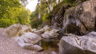
This opening stage begins in Albbruck and quickly reaches the edge of the Albschlucht, where the route becomes more rugged. A steep descent leads down to the Studinger Steg, crossing the gorge among large rock formations shaped by the river.
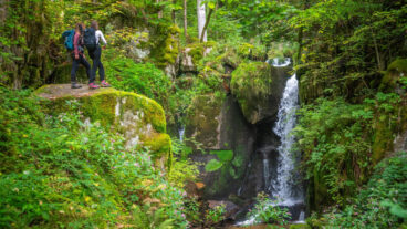
After the crossing, the trail climbs along the opposite side with elevated views, including the exposed viewpoint at Peterskanzel. Beyond Tiefenstein, the route continues through forest to Kaibenfelsen before descending to the Höllbach confluence, a natural resting spot at the meeting of two streams. From here, the path climbs past the Höllbach waterfalls and continues on to Görwihl.
Görwihl to Wittenschwand
From Görwihl, the route returns to the Alb and soon reaches the Teufelsküche, where a short detour leads to a rocky viewpoint overlooking the Albstrudel, the swirling waters of the river below. A narrow, restored path then winds along the valley side to Niedermühle, before the landscape opens into wide meadows along the Alb.
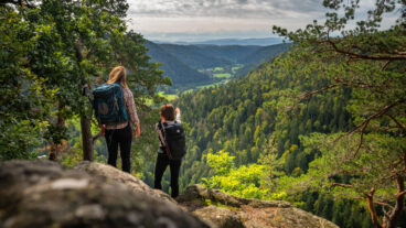
Passing through Immeneich, the stage continues with a steady climb through forest up to Wolpadingen, where a panoramic viewpoint offers distant views of the Alps in clear conditions. The final section crosses the Dachsberg through a mix of quiet woodland and open pasture, leading on to Wittenschwand.
Wittenschwand to St. Blasien
From Wittenschwand, the route leads through quiet forest to Arnoldsloch before joining an old smuggler’s path that descends steadily towards Höll. A climb then brings you up to the Bildsteinfelsen, a clear viewpoint with wide views over the Albtal, followed by a steep descent back into the valley and on to the Albstausee, where a water treading spot and lakeside paths provide a natural pause.
The trail continues along and across the reservoir before climbing again on narrow paths via Guckauchenloch and Fünfwegscheid towards Häusern. Beyond this, the route enters the rocky Windbergschlucht, passing the Windberg waterfall, before opening up to a final viewpoint over St. Blasien and its distinctive cathedral, leading down into the town.

St. Blasien to Menzenschwand
From St. Blasien, the route heads north above the town before descending to follow the Alb closely along easy forest tracks. Near Glashofsäge, the trail becomes narrower and more natural, and the route follows the eastern branch of the Menzenschwander Alb past a small reservoir and through quiet woodland.
Continuing via Hubertusplatz, a designated rest area, the path leads on to Holzmättle and a small biotope with ponds and a pavilion. From here, the trail turns east and descends with open views into the valley, finishing in Menzenschwand-Vorderdorf.

Menzenschwand to Feldberg-Passhöhe
From Menzenschwand, the route passes through open meadows towards Hinterdorf, taking in landmarks such as the wildlife enclosure, ski jump and spa facilities. Shortly after the village, the trail enters the narrow gorge of the Menzenschwander Wasserfall, where steps and paths lead through a cooler, shaded section.
Beyond the waterfall, the path continues steadily uphill across goat-grazed slopes before returning briefly to the valley floor at the Klusenmoräne. From Maria Loch, a steep and sustained climb begins, leading up to the Feldberg Passhöhe, where the stage finishes near the Menzenschwander Hütte.
Feldberg Passhöhe to Bernau
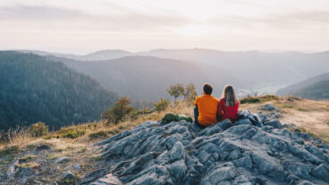
From the Feldberg Passhöhe, the route climbs steadily past the Herzogenhorn centre to the summit of the Herzogenhorn, the highest point of the Albsteig, with wide views across the Black Forest and, in clear conditions, to the Alps. The trail then descends via mixed paths to the Krunkelbachhütte, where a natural break point is reached, with an optional detour to the Kleines Spießhorn viewpoint.
Beyond the hut, the route continues downhill through alternating woodland and open pasture, passing the Scheibenfelsen with views across the Bernauer Hochtal. The trail then leads through Bernau-Dorf and follows the Bernauer Alb along the valley floor to Bernau-Innerlehen.
Bernau to St. Blasien
From Bernau-Innerlehen, the route follows the Bernauer Alb on largely flat, easy paths, staying close to the water throughout. Early on, the shaded rest area at Tannengrund offers a natural pause, before the trail continues through a quiet, undeveloped valley landscape towards Bernau-Weierle, with sections of forest, rock formations and dense vegetation.
The path remains alongside the river as it heads deeper through the valley towards Glashofsäge, reconnecting with an earlier section of the trail. From here, the route continues along the Alb back into St. Blasien, where the stage finishes in the centre of the town.
Trail Certification

Quality Trail
A Long-Distance Quality Trail meets high national standards for attractive hiking routes. These trails are carefully maintained, clearly marked, and designed to protect nature while providing a high-quality hiking experience. Regional experts monitor the trails, and they are reassessed every three years by the German Hiking Association based on criteria such as trail structure, signage, landscape, culture, and infrastructure.