Hermannsweg © TNRW
Hermannsweg
- Length
- 166 km
- Ascent
- 3896 m
- Descent
- 3685 m
- Highest
- 437 m
- Difficulty
- 3 - Strenuous
- Duration
- 47 h
GPX
Map and Elevation
I walked this trail in 2024. The map and GPX file follow the official route through the Teutoburg Forest from Rheine to Leopoldstal. When the Hermannsweg is combined with the Eggeweg it becomes the Hermannshöhen long-distance trail. Some changes have been added to this trail including bypassing the military area near Gellendorf, and a detour passing the Falkenburg by the Stemberg.

Rheine to Hörstel
The stage begins in Rheine, passing through the historic town centre and along the Ems before leaving the urban area behind. The route follows quiet paths through the flat Münsterland, characterised by a mix of fields, woodland, and scattered farmsteads, with sections along the Bevergerner Aa and through dune-like forest landscapes.
Along the way, cultural stops such as Bevergern and Kloster Gravenhorst add variety before the route crosses major waterways including the Mittellandkanal. The stage remains largely flat throughout, finishing near Hörstel at the transition towards the more elevated sections of the Hermannsweg.
Hörstel to Tecklenburg
From Hörstel, the route leaves the flat Münsterland and climbs onto the ridge of the Teutoburger Wald, where the character of the trail changes noticeably. Narrow paths lead through forest along the crest, with regular viewpoints overlooking the surrounding lowlands and landmarks such as the Nasses Dreieck.
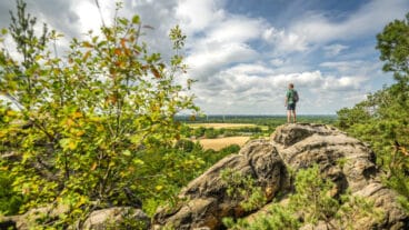
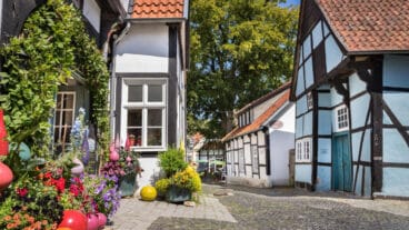
The highlight of the stage is the section across the Dörenther Klippen, where distinctive sandstone formations like the Hockendes Weib line the ridge. Continuing past further rock formations and open viewpoints, the trail gradually approaches Tecklenburg, where the stage ends in a historic hilltop town marked by half-timbered houses and its castle setting.
Tecklenburg to Bad Iburg
From Tecklenburg, the route follows the ridge of the Teutoburger Wald through varied forest landscapes, where limestone beech forests alternate with more open sandstone sections. Along the way, viewpoints and former quarry sites such as the Lengericher Canyon provide insight into both the geology and the cultural shaping of the landscape.
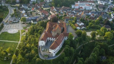
The trail continues along largely gentle terrain, passing traditional rest points such as Malepartus before approaching Bad Iburg. Here, the route leads past the Charlottensee and up to Schloss Iburg, where the stage ends in a setting defined by historic architecture and views over the surrounding hills.
Bad Iburg to Dissen
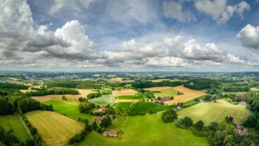
This demanding stage begins at Schloss Iburg in Bad Iburg and heads east through a predominantly forested section of the Teutoburg Forest. Early on, the route crosses the Freeden ridge, known for its seasonal highlights—especially spring wildflowers and fresh beech growth—before continuing along the ridge above Hilter. The trail features a sequence of three notable ascents, giving the stage a distinctly undulating and physically demanding character, while frequent viewpoints along the forest edge open up wide vistas over the surrounding countryside.
After crossing the A33, the route re-enters quieter woodland and continues over varied terrain before descending into the scenic Noller Schlucht. A final climb leads to the Aussichtsturm Steinegge, where expansive panoramic views over the Teutoburg Forest provide a fitting culmination to the stage. From here, a short access path leads down into Dissen am Teutoburger Wald, marking the end of a varied and rewarding ridge walk.

Dissen to Halle
This stage begins at the Aussichtsturm Steinegge and quickly establishes itself as a route defined by views and varied terrain. From Dissen am Teutoburger Wald, the trail leads along forest paths to the Luisenturm, offering sweeping vistas over the Münsterland and Ravensberg hills. A descent brings you into Borgholzhausen, known as the “gingerbread town,” where cafés provide a welcome pause before the route transitions into a more open landscape of fields and rolling countryside.
Climbing again, the trail reaches the impressive Burg Ravensberg, one of the key landmarks of the region, before continuing over the Barenberg and along the ridge toward the Große Egge, the highest point of the stage. From here, the path gradually leads toward the scenic “Kaffeemühle” viewpoint above Halle (Westfalen), offering a final panoramic perspective before descending into the historic town centre. With its combination of wooded ridges, open farmland, and frequent viewpoints, this is one of the most visually rewarding sections of the Hermannsweg.
Halle to Bielefeld
This stage begins at the scenic “Kaffeemühle” viewpoint above Halle (Westfalen) and follows the narrow ridge of the Teutoburg Forest toward Bielefeld. The route is characterised by a classic Kammweg profile, offering continuous views over the surrounding landscapes while passing through a mix of forested and open sections. Along the way, historic sites such as the Schwedenschanze and the Hünenburg provide insight into the region’s past, while the undulating terrain keeps the hike varied but manageable.
Approaching Bielefeld, the trail descends via the Osning Pass, gradually transitioning from natural ridge landscapes into more urban surroundings. Cultural highlights become more prominent, including the Heimattierpark Olderdissen and the Bauernhausmuseum Bielefeld. The stage concludes at the iconic Sparrenburg, where a panoramic view over the city provides a fitting finale to this ridge-top journey that blends natural scenery with historical landmarks.

Bielefeld to Oerlinghausen
This stage begins at the iconic Sparrenburg in Bielefeld and initially follows the elevated Promenade, a scenic ridge path offering wide views over the city. Despite its urban starting point, the route quickly transitions into quieter, forested sections of the Teutoburg Forest. Along the way, the trail crosses the 52nd parallel almost unnoticed and maintains a gently undulating profile, making it accessible while still varied. A worthwhile detour leads to the Eiserner Anton, where expansive views across the surrounding landscapes reward the short climb.
Continuing east, the route remains largely shaded beneath woodland canopy, with intermittent viewpoints along the ridge. The stage gradually approaches Oerlinghausen, where cultural highlights come back into focus. The historic Alexanderkirche provides a fitting endpoint, combining architectural interest with a sense of arrival in a traditional town setting. Overall, this section blends accessible terrain, panoramic ridge walking, and a balance of urban proximity and natural tranquillity.
Oerlinghausen to Detmold
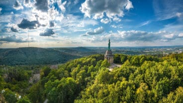
This stage runs from Oerlinghausen to the Hermannsdenkmal nearby Detmold. The route follows predominantly forested terrain along the Teutoburg Forest ridge, with intermittent viewpoints and several cultural landmarks. Early highlights include the Kumsttonne windmill remains on the Tönsberg and a historic memorial site, alongside informational listening stations that provide context on local history and landscape features.
Further along, the trail passes notable natural landmarks such as the Rethlager Quellen, the Donoper Teich, and the protected upland bog of Hiddeser Bent. The stage concludes with a final ascent to the Grotenburg, where the Hermannsdenkmal provides extensive views and serves as a prominent historical landmark marking the end of the route.
Detmold to Leopoldstal
This stage runs from the Hermannsdenkmal to Leopoldstal. The route follows the broadening ridge of the southern Teutoburg Forest, gradually approaching its transition into the Eggegebirge. Along the way, the trail alternates between mostly level ridge sections and short, steeper climbs, while offering views over the open heath and sandy landscapes of the Senne below.
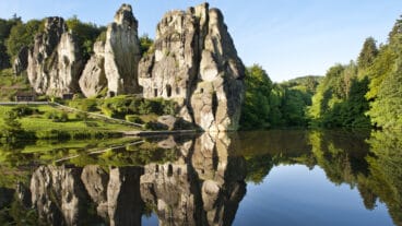
A central highlight is the passage by the Externsteine, one of the most significant natural and cultural landmarks of the region. From there, the route continues through the wooded Silberbachtal before climbing toward the Lippischer Velmerstot, where the landscape becomes more rugged and rocky. Instead of continuing on the Hermannshöhen and Eggeweg trail to the neighbouring Preußischer Velmerstot, the Hermannsweg descends toward Leopoldstal, marking the end of the stage at the edge of the Eggegebirge.
Trail Certification

Quality Trail
A Long-Distance Quality Trail meets high national standards for attractive hiking routes. These trails are carefully maintained, clearly marked, and designed to protect nature while providing a high-quality hiking experience. Regional experts monitor the trails, and they are reassessed every three years by the German Hiking Association based on criteria such as trail structure, signage, landscape, culture, and infrastructure.